Hiking
in Wells Gray Provincial Park British
Columbia
Wells
Gray Park
is British Columbia's fourth largest
provincial park, and located in the east-central part of the province.
This park is known as waterfalls park because within the park boundaries
are more than 40 different waterfalls. The most famous and spectacular
are Helmcken Falls, at 142 m (466 ft.) it is Canada's fourth highest.
The 540,000
hectares or close to 1.9 million acres of land is well known as one of
North America's finest wilderness parks that encompasses mountains, lava
beds and rocks, valleys, rivers, lakes and of course the waterfalls. The
diversity of Wells Gray Provincial Park, is due to the fact that different
types of terrain border and meet within the park boundaries and this is
the main reason you will find changes in climate and vegetation throughout.
In the northern region there is more rain and snow and it's colder during
the winter, in the southern section it's drier and tends to be warmer.
Estimates claim that Wells Gray Park features more than 500 different
types of plants, some 200 varieties of mushrooms, over 150 different birds,
50 species of animals
and it's home to the largest remaining herd of mountain caribou in southern
B.C.
Information & Services
If you would like to have your business listed, please Click Here.
History:
There are
approximately 50 known aboriginal archaeological sites within Wells Gray
Park. The Shuswap (Sepwepeme) tribe left behind most of the sites that
date to about 5,000 years ago. This coincides with the arrival of chinook
salmon in the area after the glaciers retreated. Another tribe that
made summer visits to the region was the Chilcotins. These two tribes
at times fought over possession of the hunting areas, particularly the
caribou hunting grounds. The names "Battle Mountain", "Fight Lake", and
"Indian Valley" received their names as a result of one such battle that
occurred in 1875, at a time when the caribou herds were declining. Both
tribes only utilized the park in the summer months, frequenting Battle
Mountain, Clearwater Lake, the Clearwater Valley and Mahood
Lake areas. Other regions were too mountainous, heavily forested and
lacked food supplies. Interesting sites that can be viewed today are pictographs
found on the shores of Mahood Lake. Members of the Canim Lake Indian Band
created these pictographs that can be accessed by boat.
In 1862,
the Overlanders were among the first Europeans to see the Clearwater River,
and named it for its clear coloring. The Canadian Pacific Railway sent
in surveyors into this region in the 1870's, in search of a possible rail
route through the mountains. Once the railway route was decided and the
Kicking Horse Pass was chosen, the area around Clearwater was almost void
of any activity until the early 1900's. Around this time, a few adventurous
people started homesteads in the Clearwater Valley. Between 1911 and 1914
surveys were done by Robert Lee, and in 1913 he discovered Helmcken Falls.
Over a number of years, to protect the falls, a park was discussed and
finally in 1939 Wells Gray Provincial Park came to be, it was named for
the Hon. Arthur Wellesley Gray, the provincial Minister of Lands.
Access:
Wells Gray
Provincial Park, is located just north of Clearwater
which is on the Yellowhead Highway ( Hwy. # 5). The park is 505 km (303
mi.) northeast of Vancouver and approximately 120 km (75 mi.) north of
Kamloops.
There are
five different routes into the park, but the most popular and common,
is the Clearwater Valley Road (the Wells Gray Park road), that starts
at Clearwater and takes you to Clearwater Lake.
To reach
the Murtle Lake trailhead, travel the Yellowhead Highway to Blue River.
The fifth
access is to the Flourmill Volcanoes that are located on the park's western
boundary.
The park
can also be accessed by turning off Hwy 97 at 100 Mile House. It's
an 88km drive from 100 Mile House. Be sure to fill your gas tank in advance.
Hiking:
This park
is a very popular region with canoeists, anglers, cross-country skiers
and hikers. There are a number of great hikes in the Clearwater Valley.
You will find more than 30 different hiking trails ranging from a distance
of 1 km (.6 mi.) to over 30 km (18 mi.), varying from easy walks to difficult
hiking. A number of them are day hikes, but there are several that are
interesting wilderness hikes that will take you three to four days to
complete and enjoy. If you are planning on going trekking one of the longer
hikes or on an overnight hike, check in/out is your responsibility at
the Wells Gray Visitor Centre in Clearwater.
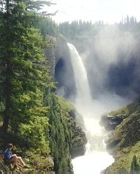
View Helmcken
Falls:
Take the
Clearwater Valley Road for 42.2 km (26.2mi.), where a short side trip
will take you to Helmcken Falls. The view point is only a few minutes
walk from the parking area.
Battle
Mountain's Caribou Meadows:
The moderate
hike to the Caribou Meadows of Battle Mountain means you will enjoy blossoming
summer flowers at their finest. This is a good five hour hike, and can
be achieved in one day. From here you can hike to Battle Mountain Summit,
Table Mountain and a few other very interesting side trips, so take your
camping gear and equipment for a three to four days hiking trek. To reach
the trailhead, take the Clearwater Valley Road for 26.4 km (16.4 mi.)
and turn right at the Battle Mountain Access for 7.2 km (4.5 mi.). Approximately
the last five kilometers of the Battle Mountain Access is a four wheel
drive road that is very difficult to get a car up. The trail starts on
the left side of the parking lot, and for the first while you make your
way along a path that switches back and forth. At Philip Lake, there is
a wilderness campsite. If you take the right fork, it will take you to
Table Mountain. Turn left at the campsite, and an hour later and you will
be at Caribou Meadows. Fight Lake, surrounded by pleasant meadows, is
another hour's hike.
Fight Lake,
is a great place to overnight, as the site offers a tiny public hut, tenting
sites, an outhouse and a bear-proof cache. From here you can take a side
trip to Branta Lake.
Battle
Mountain Summit:
Fifty-Two
Ridge and the Summit of Battle Mountain are north of Fight Lake. Continue
your hike to the summit by following the path around the left side of
the lake to the base of Fifty-Two Ridge. As you make your way along the
ridge you will notice about 20 small craters which were created by a small
volcanic eruption. The higher you climb Battle Mountain, the smaller and
more scarce the trees become. From Fifty-Two Ridge, make your way down
into Bull Valley, and on the opposite side are the final peaks of Battle
Mountain. Stay to your left, it's an hour-long climb to the summit, where
you will find an old forest fire lookout cabin, from here it's an easy
half-hour hike to the central summit, but the true summit is further east.
On a clear day you can see the Cariboo Mountains some 30 km (18.5 mi.)
in the distance and the Rocky Mountains that are about 125 km (77 mi.)
away, and to the south you can see the nine peaks of the Trophy Mountains.
Table
Mountain:
Table Mountain
is situated between Battle Mountain to the north and the Trophy Mountains
to the south and rises 2219 m (7278 ft.). This is above the treeline,
with a sweeping view of the surrounding area and alpine meadows. This
trailhead is the same as Battle Mountain and so is the trail, until you
reach Philips Creek. At Philips Creek, turn right after crossing the bridge
and you are on your way up Table Mountain. Soon, the trail starts to climb
as you work your way through a forest of balsam and old-growth spruce,
this section takes about half an hour. When the climbing becomes easier,
the trail forks, and to the right is a mountain top viewpoint of the Clearwater
Valley. The trail turns south and you make your way to the west ridge.
When this trail joins a well-used horse trail, you turn to your left.
About 45 minutes after the two trails join, the spectacular view to the
north takes in Philip Creek, Caribou Meadows, Mt. Philips and Battle Mountain.
You have reached the flattest part of Table Mountain, this large alpine
is grizzly country, so always be alert. In the middle of this meadow,
there's a sign that directs you to a "Campsight" or to "Moul
Basin" or to a cross country loop on Table Mountain that will take
six hours.
To reach
the summit, you hike through the meadows and piles of rock, which should
take you about 45 minutes. The view from the summit is unbelievable. To
the south are the Trophy Mountains, to the east you can see the Monashee
Range, to the west is Mahood Lake and to the north is Battle Mountain
(which you have just hiked). The hike back down to the parking lot should
only take a couple of hour.
Wilderness
Area:
Wells Gray
Provincial Park is a wilderness area, there are no facilities within the
park boundaries, be prepared to be self sufficient and take in needed
gear and supplies. Once you leave Clearwater, there is limited groceries
and fuel at one commercial facility between Clearwater and the park. Outside
the park there are 3 private campsites in the "Corridor" area
of the park. Tourist services you will find along the Clearwater Valley
Road are boat rentals, guides, horseback rides, gift shops, a couple of
camping sites, a sani dump, picnic areas and a boat launch. There's plenty
to see and do in Wells Gray, and it is very popular during the summer
months of July and August, but with so many different trails to hike,
you should not find the park too crowded.
For more
information on Wells Gray Provincial Park:

 British
Columbia
British
Columbia